MIGRATION OF THE
IOWA TRIBE
From: Henry R. Schoolcroft, Information Respecting the
History,
Condition and Prospects of the Indian Tribes of the United States,
vol III
(Philadelphia: Lippincott, Grambo and Company, 1953), pp. 256-58
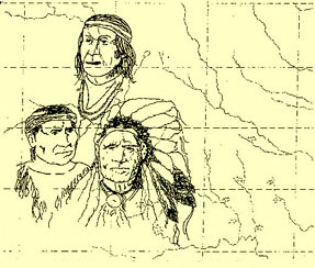
The
original outlines of the Indian map were drawn in the rough by Waw‑non‑que‑skoon‑a,
an Iowa Indian, with a black‑lead pencil on a large sheet of white paper,
furnished at the mission‑house on their reservation on the Kansas‑Nebraska
border (No. 16 on the map). It has been reduced in size, and its rigid
lines adapted to the surveys of the public lands on the Missouri and
Mississippi. The original is retained in the Indian Bureau.
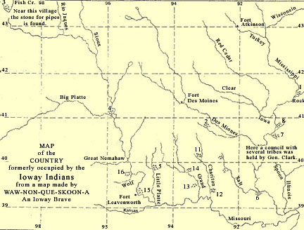
The object
of Waw-non-que-skoon-a was to denote the places where the lowas had lived
using the sixteen migrations which preceded their residence at their
present location, the Missouri; and, in truth, it nearly exhausts their
history. The marks to denote a fixed residence are a symbol for a lodge.
These are carefully preserved, with their exact relative position. Their
order, as given, is also preserved by figures. Could eras be affixed to
these residences, it would give entire accuracy to the modern part of
their history. As it is, it depicts some curious facts in the history of
predatory and erratic tribes, showing how they sometimes crossed their own
track, and demonstrates the immense distances to which they rove.
The
earliest date to which their recollection extends, as indicated by
location No. 1, is at the junction of Rock River with the Mississippi.
This was, manifestly, in or very near Winnebago territory, and confirms
the traditions of several of the Missouri tribes. From this point they
migrated down the Mississippi to the river Des Moines and fixed themselves
at No. 2, on its south fork. They next made an extraordinary migration,
abandoning the Mississippi and all its upper tributaries, and ascending
the Missouri to a point of land formed by a small stream, on its east
shore, called by the Indians Fish Creek, which flows in from the direction
of, and not far from, the celebrated Red Pipe stone quarry, on the heights
of the Coteau des Prairies, No. 3.
They next
descended the Missouri to the junction of the Nebraska, or Great Platte
River, with that stream, No. 4. They settled on the west bank, keeping the
buffalo ranges on their west. They next migrated still lower down the
Missouri and fixed themselves on the headwaters of the Little Platte
River, No. 5.
From this
location, when circumstances had rendered another change desirable, they
returned to the Mississippi, and located themselves at the mouth of Salt
River, No. 6. Here passed another period. They next ascended the
Mississippi and settled on its east bank, at the junction of a stream in
the present area of Illinois, No. 7. Their next migration carried them
still higher on that shore, to the junction of another stream, No. 8,
which is well nigh to their original starting point at No. 1.
They
receded again to the south and west, first fixing themselves on Salt
River, No. 9, above their prior site, No. 6, and afterwards changing their
location to its very source, No: 10. They then passed, evidently by land,
to the higher forks of the river Chariton, or Missouri, No. 11 and next
descended that stream to near its mouth, No. 12. The next two migrations
of this tribe were to the west valley of the Grand River, and then to its
forks, No. 14. Still continuing their general migrations to the south and
west, they chose the east bank of the Missouri, opposite the present site
of Fort Leavenworth, No. 15, and finally settled on the west bank of the
Missouri, between the mouth of the Wolf and Great Namahaw, No. 16, where
they now reside.
These
migrations are deemed to be all of quite modern date, not exceeding the
probable period to which well known tradition could reach. They do not, it
would seems aspire to the area of their ancient residence on the lower and
upper Iowa Rivers, and about the region of St. Anthony's Falls.
We are
taught something by these migrations. They were probably determined by the
facility of procuring food. They relied, ever, greatly on the deer, elk,
and buffalo. As these species are subject to changes, it is probable they
carried the Indians with them. It is not probable that their locations
were of long continuance at a place‑not over a dozen years at a location,
on the average. It might be longer at some places, and less at others.
This would not give a period of more that 180 years, before their arrival
at their present place. Marquette found them, in 1673, at the mouth of the
Des Moines. This, it is seen, was their first location.
Explorations in Iowa History Project
Malcolm Price Laboratory School
University Of Northern Iowa
Cedar Falls, Iowa
©COPYRIGHT 2003 University of Northern Iowa
Lynn.Nielsen@uni.edu
Duplication for Instructional purposes only.
Credits: Logo and site design by ITS CET
Documents courtesy of the State Historical Society of Iowa
|